


Ever wonder how the Township, Range and Section are determined? Well get ready for a history lesson.
Our story begins in 1785, toward the end of the American Revolution as the U.S. received new land in thanks to the Treaty of Paris. In order for the U.S. to properly assess the new land, the Public Land Survey System (PLSS) was developed to plat or divide real property for sale or settling. The PLSS is now the primary surveying method for the majority of America, excluding the original 13 colonies and Texas.

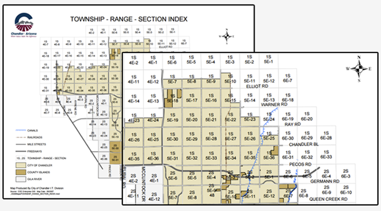
How the System Works
First, a baseline is established that runs east to west. In Arizona, it’s Baseline Road. Then a principal meridian, which runs north and south is defined. Our principal meridian is the Gila River or roughly 115th Avenue. Next, lines parallel to the baseline are plotted along the map. These are called standard parallels. These three lines, the baseline, principal meridian and standard parallels, form a foundation grid that allows for more detailed survey work.

Township lines that run parallel to the baseline are plotted, typically in intervals of 6 miles. Range lines that run parallel to the principle meridian are plotted, usually in 6 mile intervals.

Once the township is established it is then divided into 36 sections measuring 1 square mile, giving us what we see in our tax records today.

Here is an example using Monsoon.

This property is in section 31, 1 Township north of the baseline and 4 Ranges east of the principle meridian.

Anonymous
I’m deaslilng with some old mineral deeds for parcels located in Cherry County Nebraska. But none of the townsip/range descriptions match. Example: “Township 35N, Range 29W”.
Was the system changed sometime after 1955?
James Marcus
It’s possible there is a local deviation to how it was done in Nebraska. Have you tried this search: https://sso.nebraska.gov/repo-new/search-str.html.